


NOAA: Gulf of Mexico Dead Zone Still Significant
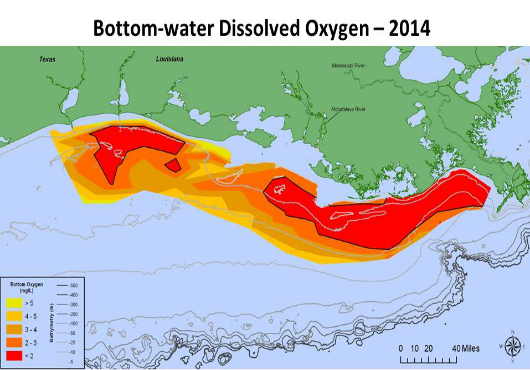
NOAA and EPA-supported scientists have mapped the Gulf of Mexico dead zone, an area with low oxygen water, measuring 5,052 square miles this summer — approximately...
NOAA and EPA-supported scientists have mapped the Gulf of Mexico dead zone, an area with low oxygen water, measuring 5,052 square miles this summer — approximately the size of Connecticut. The measurements were taken during the 30th annual hypoxia survey cruise from July 27 to August 2.
This area falls within the predicted range of 4,633 to 5,708 square miles forecast by a suite of NOAA-sponsored models and confirms the accuracy of the models and their utility for guiding management of nutrients in the Mississippi River watershed.
The size is smaller than the 5,840 square miles recorded last year but still greater than the Mississippi River/Gulf of Mexico Watershed Nutrient (Hypoxia) Task Force target of less than 1,900 square miles — meaning nutrients from the Mississippi River watershed are continuing to affect the nation’s coastal resources and habitats in the Gulf.
The task force consists of five federal agencies, 12 states and the tribes within the Mississippi/ Atchafalaya River Basin, and was established in 1997 to reduce and control hypoxia in the Gulf of Mexico.
Individual components of the final ocean acidification risk index for each census area showing the communities with the highest risk are in the Southeast and Southwest of the state.
The largest Gulf dead zone ever recorded occurred in 2002, encompassing 8,481 square miles. The smallest recorded dead zone measured 15 square miles in 1988. The average size of the dead zone over the past five years has been about 5,500 square miles.
[caption id="attachment_81331" align="alignnone" width="530"] Distribution of bottom-water dissolved oxygen July27-August1, 2014.[/caption]
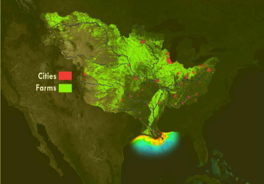
These nutrients stimulate an overgrowth of algae that sinks, decomposes, and consumes the oxygen needed to support life in the Gulf.
“The Mississippi River discharge levels and associated nutrient data, supplied in May by the USGS, pointed to an average size hypoxia area based on the inputs which fuel mid-summer’s dead zone algal growth,” said Nancy Rabalais, Ph.D., executive director of the Louisiana Universities Marine Consortium (LUMCON), who led the survey cruise.
“If the heavy rains in the upper Midwest in June and the record high nitrate concentration in the Mississippi River at Baton Rouge on July 18 had coincided with a later survey, chances are that the area would have been larger.
The high phytoplankton biomass and large area of fresher water would have eventually led to more bottom-water hypoxia.”


Türkçe karakter kullanılmayan ve büyük harflerle yazılmış yorumlar onaylanmamaktadır.